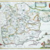


Harris (John)
A Map of the County of Kent,
John Harris, 1719.
Sold. Contact us if you would like notifications on this or similar items in the future, or if you have a similar artwork you would like to sell.
a large and very decorative map from ‘The History of Kent’ by John Harris, derived from the 1596 map of the county by Philip Symondson, which had already been reissued by Stent in 1650, this present map with an inset view of ‘Dover Castle and Towne’ in the lower right corner, columns listing ‘Lathes, Bayliwicks, Hundreds, Market Towns, City’s with their Cathedrals and Parish Churches, Ports (and their Members) lying in Kent, Franchises’, lower left, the title cartouche upper left, the whole composition bordered with 118 coats-of-arms, the county and surrounding parts detailed with depictions of the churches, woodlands, rivers and major roads, the Thames Estuary detailed with sand banks, 3 ships and a sea monster,
engraved map by Samuel Parker, on two sheets, joined, with fine hand-colouring, 570 x 820 mm. (22 1/2 x 32 1/4 in), original folds, sheet edges slightly chipped, but with good margins so all well outside the map,
Related products


British Maps
Greenwood (Christopher and John)
Map of the County of Southampton from an Actual Survey made in the Years 1825 & 1826,