Skip to content
  • Pictures Specialist: Valuations | Cataloguing | Research | Auction Advice
  • Blog
  • About
  • Contact
  • Pictures Specialist: Valuations | Cataloguing | Research | Auction Advice
Robert Hall

Prints, Maps, Drawings & Watercolours

  • Home
  • Browse
  • Categories
    • Travel
    • British Topography
    • Natural History
    • Art & Architecture
    • Transport & Engineering
    • Caricatures
    • Drawings & Watercolours
    • Old Master Prints
    • Modern and Contemporary Art
    • Maps & Atlases
      • British Maps
      • Foreign Maps
  • Login
  • Basket / £0
    • No products in the basket.

  • Basket

    No products in the basket.

Gallery / Maps & Atlases / British Maps
Add to Wishlist

Marchant (J.)

Brighthelmstone from an actual Survey,

£275

Brighton, J. Marchant, and R. Paine, also Lewes, J. Baxter, 1808.

In stock

SKU: DW0195 Categories: British Maps, Etsy 2022 Tags: Brighton, City Plans, English Architecture, PBFA Feb Travel, Sussex
Categories
  • Art and Architecture
  • British Topography
    • London
    • Panoramas - British
    • Sussex
  • Caricatures
    • Portraits
  • Christmas 2022
  • Drawings & Watercolours
  • Etsy 2022
  • Maps & Atlases
    • British Maps
    • Foreign Maps
  • Modern and Contemporary Art
    • Etching Revival
  • Natural History
  • Old Master Prints
  • Photographs & Photographic Art
    • Space Exploration
  • Sports & Pastimes
  • The Paintings of Christopher Hall
  • Transport & Engineering
  • Travel
    • Panoramas - Foreign
  • Uncategorised
Keywords
Agriculture Animals Antique Prints of Italy Astronomy British Maps Caricature caricatures Celestial christmas20 Church Architecture City Plans City Views Classical Architecture Classical Mythology Costume County Maps Engineering English Architecture Etsy22 Exploration Geology Hastings Italian Architecture Italian Art Italy Lancashire Livestock London Military Modern Art Napoleonica NASA Photographs PBFA523 PBFA Feb Travel Politics Portraits Railways Rome Satire Scotland Social History Sussex Theatre Transport Yorkshire
  • Description

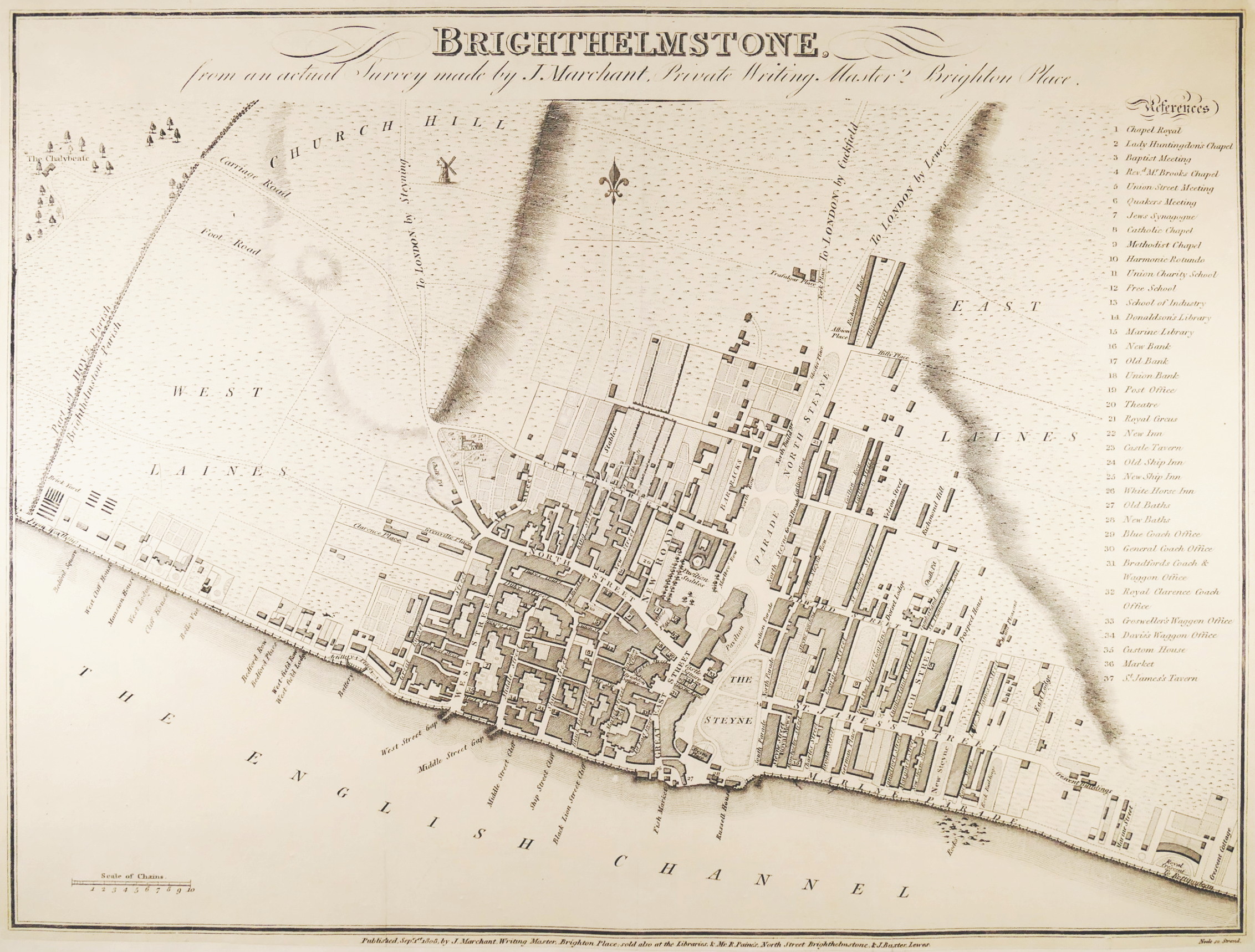
‘made by J. Marchant, Private Writing Master, 2 Brighton Place’, a scarce, locally published, plan of Brighton during a period of significant transition, not just of its name, but also of its architectural development. It shows the recently built Royal Crescent, in the south east corner, and the new Pavilion Stables, then under construction, here showing the plan of William Porden’s distinctive dome, though before Henry Holland’s neoclassical original design for the Royal Pavilion itself underwent John Nash’s famous Indo-Islamic makeover in 1815. This plan, although almost certainly also separately published, did appear in this form in ‘Attree’s Topography of Brighton’, published in the same year, 1808. It appeared again with revised presentation of the title and key in ‘Sickilmore’s (or Sicklemore’s) Epitome of Brighton’, in 1809, by which time Marchant had moved house from Brighton Place to 41 North Street. The plan identifies the three primariy areas as West Laines, East Laines and Church Hill, and extends from the parish boundary with Hove, and the chalybeate spring just beyond, to the west, across to Royal Crescent in the east. The northern extent of urban development at this time was around the lower ends of Richmond Place and Albion Street, near the newly emerging Trafalgar Place, now Trafalgar Street, leading off York Place, at the point where this main road to London via Cuckfield ran out across open fields,

engraved plan by Samuel Neele, 310 x 410 mm. (12 1/4 x 16 1/8 in), the sheet laid onto a fine conservation paper support, faint old folds, 


Related products

Add to Wishlist

British Maps

Lewis (Samuel) Publisher.

Map of S.E. England [from A Map of England & Wales],

£200
Add to Wishlist
Out of stock

British Maps

Collins (Greenville)

A New & Exact Survey of the River Dee or Chester-water,

Add to Wishlist
Out of stock

British Maps

Rapkin (John)

Brighton,

About

Specialising in antique prints, maps, atlases, plate books, drawings and watercolours, with a penchant for caricatures, Old Master prints and etching revival.

Terms & Conditions

Latest News
  • 23
    Jun
    Sir Giles Gilbert Scott OM, FRIBA (1880-1960) Comments Off on Sir Giles Gilbert Scott OM, FRIBA (1880-1960)
  • 26
    Apr
    Not just penal reform Comments Off on Not just penal reform
  • 14
    Feb
    Valentine’s Day 2020 Comments Off on Valentine’s Day 2020
  • 19
    Nov
    NASA Photography | Apollo 12 Moon Landing #OTD Comments Off on NASA Photography | Apollo 12 Moon Landing #OTD
Tags
Agriculture Animals Antique Prints of Italy Astronomy British Maps Caricature caricatures Celestial christmas20 Church Architecture City Plans City Views Classical Architecture Classical Mythology Costume County Maps Engineering English Architecture Etsy22 Exploration Geology Hastings Italian Architecture Italian Art Italy Lancashire Livestock London Military Modern Art Napoleonica NASA Photographs PBFA523 PBFA Feb Travel Politics Portraits Railways Rome Satire Scotland Social History Sussex Theatre Transport Yorkshire
Newsletter

Copyright 2023 © ROBERT HALL | PAINTINGS, PRINTS, MAPS, DRAWINGS & WATERCOLOURS | LONDON
  • Home
  • Browse
    • Categories
      • Travel
      • British Topography
      • Natural History
      • Art & Architecture
      • Transport & Engineering
      • Sports & Pastimes
      • Caricatures
      • Drawings & Watercolours
      • Old Master Prints
      • Modern and Contemporary Art
      • Maps & Atlases
        • British Maps
        • Foreign Maps
  • Blog
  • Contact
  • About
  • Terms & Conditions
  • Login

Login

Lost your password?