
Railway Clearing House (The ).
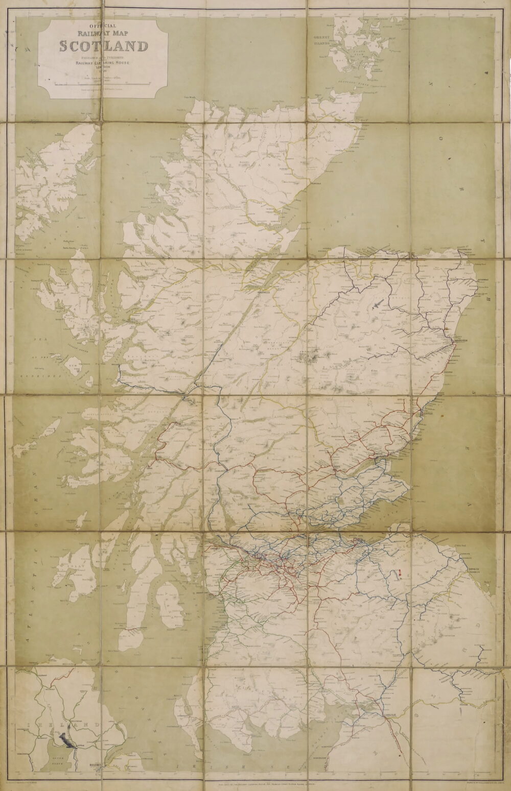
Official Railway Map of Scotland,
Sold. Contact us if you would like notifications on this or similar items...
Drawn and engraved by J. & W. Emslie, on a scale of 1 inch to 7 1/2 miles, a well-worn example of a working document supplied to the railway industry periodically over the organisation’s existence. The Railway Clearing House, or RCH, was founded in 1842 to facilitate the fair disbursement of revenue between the separate railway companies who provided an overlapping service. In a related role it began to produce Railway Junction Diagrams, or RJDs, in the late 1850s, and issued what are considered to be the finest series of railway maps ever produced in the United Kingdom. With the numerous mergers of railway companies, and their eventual nationalisation, the RCH was finally disbanded in 1963.
This particular copy bears the scars and patina of participating in the industrious life of a travel office from the 1920s onwards, both to the reinforced covers and to the well-thumbed and oft-refolded map sheet. The linen verso of the map bears the ink property stamps of the famous travel company, Thomas Cook & Son, British Dept., Ludgate Circus, dated 1922. That famous cmpany had an intimate working relationship with the railways in Britain, and was infact nationalised alongside them all in 1948, to become part of the British Transport Commission. There is also a hand-written label pasted inside the front cover stating ‘Property of …(name removed)… British Department Chief Office’. The large, bold, map is relatively simple in presentation, featuring only the relief of mountains and rivers on the uncoloured land, set in the solid wash of green sea, with no roads or urban areas to clutter the complex network of railways. These are distinguished by a variety of colours, but each is also named alongside, as there is no colour key provided. From England arrive the London & North Western, Midland and the North Eastern lines, which connect directly or indirectly to the Caledonian, Glasgow & South Western, North British, Portpatrick and Wigtownshire, Highland, and Great North of Scotland lines. There is also the short Campbelltown to Machrihanish line across the Kintyre Peninsula, and in Northern Ireland are the Great Northern, Northern Counties, and Ballycastle lines,
coloured lithograph map, printed by McCorquodale & Co. Ltd., 1110 x 715 mm. (43 3/4 x 28 1/8 in), dissected and linen-backed, surface dirt and wear, some short splits in folds of linen backing, occasional ink splashes, folding into original black cloth boards, gilt-lettered on upper cover, edges reinforced with black cloth tape, worn, 8vo, 1920.
Related products